Category Archives: HISTORY

Temescal Valley Landmarks

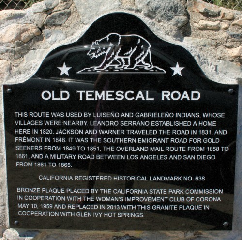
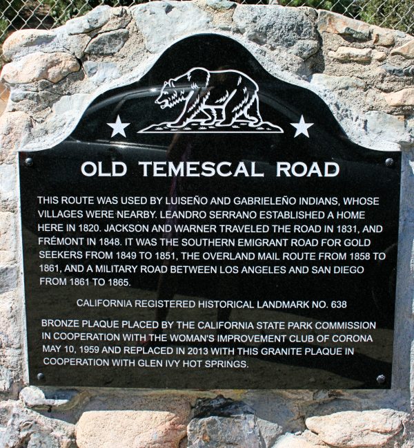
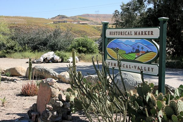
This landmark is on Temescal Canyon Road just south of Glen Ivy Road. Read about the re-dedication ceremony HERE.

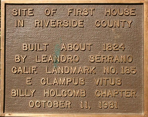
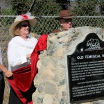
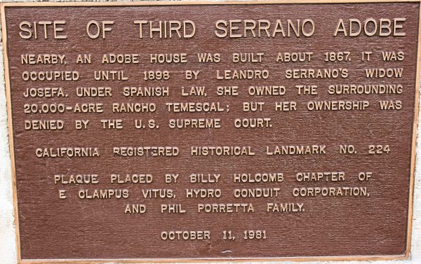
The reputed location of the first Serrano adobe is in the vicinity of Lawson and Temescal Canyon roads, marked by a very old pepper tree and the boulder underneath it. Years ago, the plaque on top of the boulder, designating the spot as the site of the first house in Riverside County, was stolen. The plaque had been placed there in 1981 by the Billy Holcomb Chapter of E Clampus Vitus, a fraternal organization responsible for many of the plaques denoting historical landmarks in the area. The good news – the plaque turned up in a garage and the homeowner sensing its importance contacted the Billy Holcomb Chapter and returned it. We hope to reunite the plaque with the boulder, but not until the area can be better protected.

This landmark is situated east of the I-15 at the Temescal Canyon Road interchange, across the street from the Shell Station. Also located there are two tanning vats that date back to Leandro Serrano.

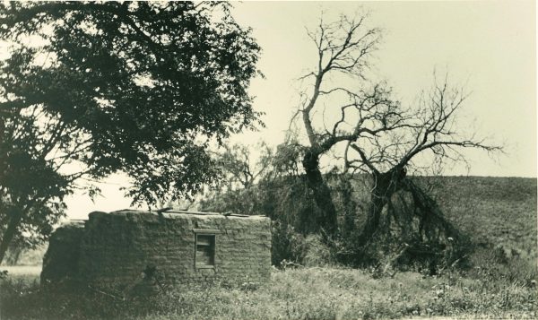
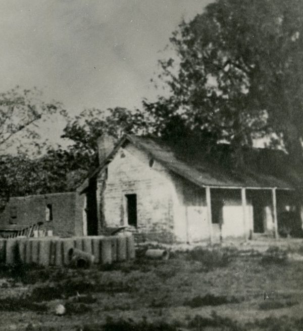
The ruins of the third Serrano adobe, circa 1930. Photograph courtesy of Corona Public Library


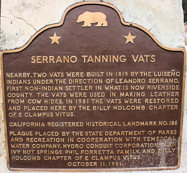
Through the years, very little of the Serrano legacy has been preserved. What still exists are two tanning vats that Serrano used to process leather. They also are situated across the street from the Shell Station. This isn’t the original location of the vats, which were moved and reconstructed at this site years ago.

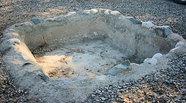
One of the two tanning vats.

The area where the vats and landmarks are located was the subject of a community beautification project in April 2015. Read more about the Cleanup HERE.

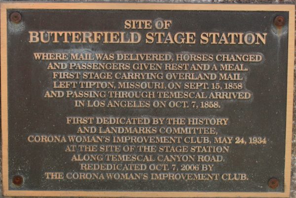
The Butterfield Overland Mail operated along a southerly route between St. Louis and San Francisco from 1858 to the onset of the Civil War in 1861. The stagecoaches carried passengers and mail over the 2,800-mile route with company stations placed from 9 to 60 miles apart where horses and mules could be exchanged and supplies restocked. The line ran through Temescal Valley and generally followed the route of the Southern Emigrant Trail, today’s Temescal Canyon Road. The Rancho Temescal Station was situated about 5 miles northwest of Glen Ivy Hot Springs near today’s location of Dos Lagos Golf Course. This landmark was moved when the Dos Lagos homes were built and is now located within the shopping center near the lakes.

Ruins of the Rancho Temescal Station. Photograph courtesy of Corona Public Library

THE BICENTENNIAL LOGO

UNVEILING: From left, Tracy Davis, We Are Temescal Valley Identity Committee chairman;  Jannlee Watson, Temescal Heritage Foundation board member, and Cathie Smith, Temescal Valley Community Faire Committee,  unveil the new logo at the April Bicentennial Committee meeting.

Thank you, Cathie Smith, for the beautiful artwork!

This spring, and as May’s Temescal Valley Community Faire was quickly approaching where the community’s 200th Birthday would be launched, the Bicentennial Committee still was in a quandry over the logo. Needed was artwork easily identifiable as Temescal Valley, but unique enough to say, “Hey look — something special is happening!”

With only a week to get the Faire flier to the printer, someone said, “Why re-create the wheel — let’s use the current Temescal Valley logo, just age it 200 years ago.”

The original logo was introduced in 2007 as part of the Temescal Valley Design Guidelines created by Riverside County for the Temescal Valley Municipal Advisory Council. The logo can be seen on community signs throughout Temescal Valley, the I-15 freeway monument signs at the entrances to the community, on local businesses and published material.

It was Sycamore Creek resident Cathie Smith whose graphic design know-how brought the vision to life, redesigning the current logo to better reflect Temescal Valley in the time of Leandro Serrano.

Gone are the palm trees, modern homes and orange groves, which have been replaced with adobes, grazing cattle, beehives, orchards and grapevines, a marauding bear and, yes, flowing water. The Bicentennial logo has three adobes, depicting the three built by Serrano, and places one of the structures on a hill. The exact location of the second adobe is unknown, only that Serrano built it on a hill to get a better view of approaching strangers, and that it was built in close proximity to where the first adobe was located near Lawson and Temescal Canyon roads.

The new logo has been imprinted on T-shirts, mugs and aprons that can be purchased at all Bicentennial events and at the monthly Temescal Valley Municipal Advisory Council and We Are Temescal Valley meetings. T-shirts are $20 and the aprons and mugs are $15. Orders are being placed now for hats and license plate frames.


TEMESCAL TIN MINE

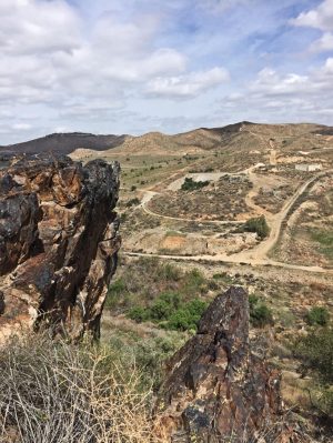
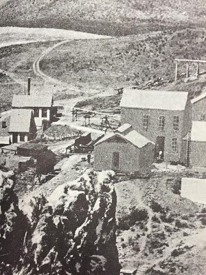
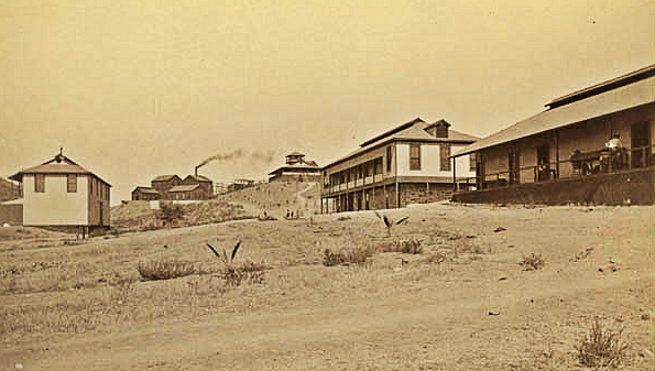
Buildings at the old tin mines in the early 1890s.

‘There’s tin in them thar hills!’

By TOM RITCHINS
HISTORY OF CORONA
Facebook page

When Daniel Sexton journeyed to Southern California in 1841, he settled down and married the niece of Chief Solano of the Cahuilla Indians. Through his positive relationship with the Indians, Chief Solano instructed his medicine man to show Sexton a sacred hole in the ground where a metallic substance was located and that the Indians used as tribal medicine.

WANT MORE?

WESTERN MINING HISTORY
Temescal Tin Mine Facts
______________________________________
THE CAJALCO DIGS:
Exploring an Early California Mining Camp
By T.A. FREEMAN
______________________________________
BACK IN THE DAY:
Tin Mining Once
Had Inland Base
By STEVE LECH
Riverside County Historian
______________________________________

Sexton thinking it was silver let the word out, and by 1859 a load was extracted and surprisingly the metal was identified as tin. The news of the tin discovery made national attention. Up to this point there were no tin mines in the United States and this was our nation’s first big tin discovery.

In 1860 the hole with the tin turned into the Cajalco Mine and business operations were organized as the Temescal Mining Company. With a staff of 16 miners, by 1865 the mine shipped five tons of ore to the San Francisco Vulcan Iron Works for crushing, then shipped to Wales in the United Kingdom for refining.

During 1868, San Jacinto Tin Company purchased the mine and increased the staff to 30 men working the mine. Their purchase was a success. The miners started crushing the ore on-site, and then would ship the concentrate to San Francisco in sacks to the Mosheimer Works for smelting and refining. It was at these works that in December of 1868, the first bar of American-mined tin, weighing 85 pounds, was produced.

It was technology that really put our nation’s Cajalco tin mine on the map. In the 1880s it was discovered that when adding tin to metal cans (tin cans), food could be packaged and the containers wouldn’t rust, thus making tin invaluable for the preservation of food.

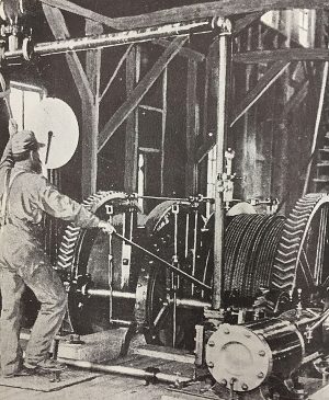
This really kicked mining activities into high speed. By 1891 there were 250 men working the mine, 82 veins of ore were discovered, and according to James Van Allen of the Scientific American, he visited the mine and estimated that workers were stamping 75 tons of rock daily.

Not only was the tin mine successful, the owners of the mine also decided to mix politics with their mining. Desiring to sell their tin at higher prices, the mine petitioned congress to slap a tin export tariff on Great Britain. To influence congressional decision in their favor, they produced 500 small bars, stamped them, and sent one to each member of congress bragging, in essence, that they could supply enough tin for the entire country. Even the President of the United States Benjamin Harrison sided with the mines’ political efforts. While journeying through California via train, the president stopped at the train station in Corona, mounted a platform and took a picture next to a sign on top of a tower of tin bars that read, “The First American Tin Mine, April 23, 1891.”

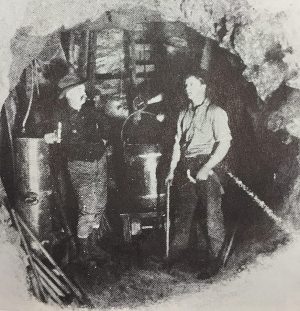
The political scheming worked. Congress passed the McKinley Tariff, and the Temescal mine had the advantage. However, it turned out it was all for nothing. Just one year later in 1892, the tin veins ran dry, and the tin mines closed.

That was pretty much the end for our nation’s tin mining. Except for a short time during World War II when the tin mines reopened briefly for war purposes, the mines have sat closed and dormant to this day.

Notes and Sources from the author:
1. Photos are part of the Corona Library Heritage Room Collection
2. “The Temescal Tin Fiasco” by Donald Chaput. Copy of this publication can be found at the Corona Library W.D. Addison Heritage Room
3. Current pictures of Temescal Tin Mine are property of the author

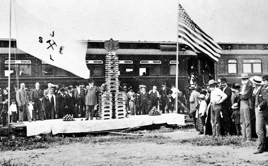
President Benjamin Harrison in 1891 makes a train stop to admire a tower of tin from the Temescal Tin Mine. The sign read “The First American Tin Mine, April 23, 1891.”
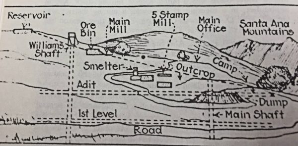
An early map depicts the layout of the mine.


Modern-day photo on the left was shot in about the same proximity as the photo on the right taken about late 1880s or early 1890s.

Frank Miller, proprietor of the Mission Inn (then known as Hotel Glenwood) minted tokens circa 1880s from Temescal Tin Mine ore. One side read, “Tin Mine 12 miles from Riverside. The greatest orange growing district in the world.” This token sold at auction in 2017 for $250.

Temescal Tin Mine ruins photographed in 2015.

Riverside County beekeeping began in Temescal Valley

From the “History of San Bernardino and Riverside Counties” Volume One, published by the Western Historical Association in 1922, under the section “Beekeeping in Riverside County,” and written by beekeeper L.L. Andrews.

“About 1872, there was an apiary in the Temescal Valley, a few miles east of what is now Glen Ivy and Cold Water Canyon. The bees were brought in by a negro from Mexico or a district near the Mexican border. These are the first bees of which we can find any trace.

“In the year 1874, Mr. James Boyd hauled bees for Mr. D. McLeod from near where Escondido now stands to the Temescal Valley. This apiary was later sold to Morse and Compton as was noted in the Riverside Press of December 28, 1878. Mr. Compton at this writing, January 1922, still resides in the Temescal Valley and keeps an apiary on the same location one quarter of a mile from Lee Lake. This territory is near where the San Diego and San Bernardino County line crossed the valley before Riverside County was cut off.

“There was honey on exhibition from San Diego County at the fair of the Southern California Horticulture Society held in Los Angeles in October 1878. There was also honey from the apiary of Captain Webb of Box Springs and it was pronounced as “white as paper.” In the Riverside Press of December 27, 1879, is an item which reads: “Anderson Brothers of Temescal have received returns from their honey crop of 14,400 pounds. This honey has been kept for two years for a better market and was sold in San Francisco for 15 cents per pound. The cash receipts were $2,160.”

“Temescal Valley, like other vast tracts of land throughout Southern California, was covered with wild brush of all kinds. Black sage, white sage, wild buckwheat, sumac, wild alfalfa, etc., were found in abundance, and furnishing plenty of nectar offered promising locations for the apiarist.”

TV resident is in Civil War re-enactment

(We asked Temescal Valley resident Rob Mucha to share his experience posing as a Union soldier during the Civil War re-enactment staged at Tom’s Farms in October. He shares his story here. Rob, since October, has appeared in other re-enactments.)

VIEW PHOTO GALLERY  HERE

Temescal Valley resident Rob Mucha carries the company flag.

Temescal Valley resident Rob Mucha carries the company flag.

By ROB MUCHA

When I heard that there was going to be a civil war re-enactment in my own valley I got a strong urge to enlist in the cause.

I’ve always been interested in the civil war since I was a kid, have visited several of the battlefields including Gettysburg, and have a couple friends around the country who participate in them, but I’ve never had the opportunity to participate on such a personal level. Plus, we had just finished our own not so civil war just weeks before (Corona annexation defense), and the timing seemed rather fitting.

Volunteering was easier than I thought it would be. I showed up the day before as the camps were setting up and the first person I talked to just happened to be the head of one of the Union divisions and had an opening and some loaner gear. He told me to come back the next day a couple hours early and they’d get me all set up. The best part is that he ran an artillery group so I’d be able to shoot cannons all day … there aren’t very many opportunities in my normal life to shoot cannons so I didn’t get much sleep the night before.

The uniform fit great and I was given some basic training about how to look and act in camp. The troops spend a lot of time, effort and money in making it look as real as possible, and there were justifiable expectations about how to act in uniform.

I found it interesting that both sides saluted the other side’s top leaders out of respect. The various troops come from all around the state/country and are very tight within their own group and promotions are earned over time. They take all aspects very seriously and people are addressed if they fall out of line.

Of course I fell out of line. I did a lot of things right and thought I blended in pretty well, but there are so many moving parts that it is pretty inevitable for a newbie. My troop was real patient, but when you get around the higher leaders they expect you to know your duties. That seriousness added a lot to the overall experience.

My first role was to carry and store all the black-powder charges for one Union cannon, a parrott cannon which is one of the larger ones and accurate up to a mile I’m told. I didn’t really fully understand how dangerous the role was until several people mentioned to me not to let any smokers around me, and to keep gloves on when handing a charge to the cannon loader. Good tips, considering I was holding 10 or so charges! That role stands back by the leaders until an individual cannon charge is requested. It was great listening to the upper leaders discussing the order of the blasts and watching the battle unfold from that perspective. I was supposed to remain pretty serious but I saw a picture where I had a huge smile on my face after a barrage of cannon blasts fired. Couldn’t help it!

It was also neat just walking through the camps in uniform. I even had the opportunity to carry our flag out to the battlefield which was also pretty special, especially considering what that meant historically. It would have been neat anyway, but running into people who I actually knew from the area added another level to it.

For the second battle my role changed to inserting and pulling the cord that actually fires the cannon. This is a lot more complicated and dangerous than it sounds, but it is absolutely thrilling and addictive! My troop held a little ceremony for firing my first cannon which was pretty cool. At the end of two days and four battles I really felt like part of the troop and was invited to participate in future events at other locations. Will I go dress up and fire cannons another day? No doubt!

Photo Gallery: Civil War re-enacted here

Slideshow: Honoring Old Temescal Road

Old Temescal Road rededicated

marker

The new marker replaces the bronze marker that was dedicated in 1959 and was stolen several years ago. The new marker is granite.

About 75 people attended the Glen Ivy Hot Springs dedication ceremony on Saturday, Sept. 7 to re-establish the marker designating Old Temescal Road as a California historical landmark.

VIEW SLIDESHOW HERE

First dedicated in 1959 as California historical landmark No. 638, the bronze marker was stolen several years ago, and was replaced with a new marker unveiled at the ceremony. The marker is on Temescal Canyon Road, about 200 feet south of Glen Ivy Road.

Old Temescal Road played a major role in southern California history. It was the route used by the Luiseno and Gabrieleno Indians to reach their nearby villages. Leandro Serrano, the first non-native settler in Riverside County, built a home in the area in 1820. Gold seekers, including John Fremont, used the road from 1849 to 1851, and it was the route for the Butterfield Overland Mail coaches from 1858 to 1861.

The Corona Historic Preservation Society, Chandler Aggregates and the Temescal Heritage Foundation assisted Glen Ivy Hot Springs with the dedication.